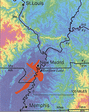
New Madrid Fault Zone
Memphis is located along the New Madrid fault zone. The zone includes a large series of faults beneath the continental crust in an area known as the Reelfoot Rift. This fault system extends some 150 miles in length, from near Marked Tree, Arkansas, through northwest Tennessee, the boot heal of Missouri, extreme west Kentucky and to the southern part of Illinois. The rift formed about 500 million years ago when plate tectonics cause the region to be stretched in a northwest-south east direction. In reaction to this stretching, rocks slowly dropped down (approximately 1 mile) in an area 40 miles wide and 300 miles long, running northest-southwest.
Reelfoot Rift
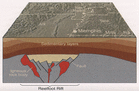
As seen in the diagram right, the Reelfoot Rift was then covered by approximately 3000 feet of sediment. This sediment was deposited by an ancient sea which covered the central part of the United States near the end of the Cretaceous period. Stretching of the earth's crust beneath the central portion of the United States caused the crust to begin to subside. This allowed the ocean to reach what is southern Illinois today. For more historical geology information follow this link to the Memphis Aquifer.
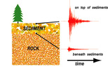
The New Madrid fault system has the greatest potential for earthquake damage of any area east of the Rocky Mountains. And, although these damaging earthquakes are much less frequent than in California, they hold the potential for much greater damage. This potential for damage is due to the sediment covering of the faults of the area. Earthquake waves are amplified as they travel through sediments and therefore travel a much greater distance. These waves can cause damage and earthquakes to be felt many hundreds of miles farther than earthquakes in the California area.
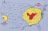
For example, the picture (right) shows the San Francisco, California, earthquake of 1906 (magnitude 7.8). It was felt 350 miles away in the middle of Nevada. Whereas the New Madrid earthquake of December 1811 (magnitude 8.0) rang church bells in Boston, Massachusetts, 1,000 miles away. As described above, differences in geology east and west of the Rocky Mountains cause this strong contrast.
Today, the crust in this same geographic region is going through east-west shortening and the ancient Reelfoot Rift has been reactivated again causing earthquakes in the area.
Today, the crust in this same geographic region is going through east-west shortening and the ancient Reelfoot Rift has been reactivated again causing earthquakes in the area.
Back to CERI.
Next site on the trip.
Back to Reelfoot Lake.
Next site on the trip.
Back to New Madrid Museum.
Next site on the trip.
Next site on the trip.
Back to Reelfoot Lake.
Next site on the trip.
Back to New Madrid Museum.
Next site on the trip.